Namibian Geography
Namibia a Land of Contrasts and Vast Beauty
Namibia's natural beauty is as captivating as it is unforgettable

Namibia, located in southwestern Africa, is a country of striking geographical diversity. From ancient deserts to rugged mountains, vast savannas, and a wild Atlantic coastline, Namibia's landscape is as dramatic as it is varied. Its unique geography not only shapes its climate and ecosystems but also defines the character and culture of the country.
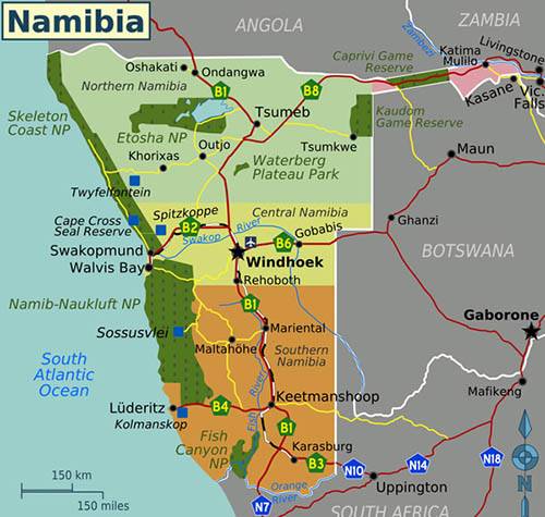
Location and Borders. Namibia is bordered by Angola to the north, Zambia and Botswana to the northeast and east, South Africa to the south, and the Atlantic Ocean to the west. It also shares a short boundary with Zimbabwe near the Zambezi River. Its strategic position includes the Caprivi Strip, a narrow panhandle of land that stretches eastward, giving Namibia access to the Zambezi and Chobe Rivers.
Major Geographic Regions. Namibia can be divided into four major geographic regions, each with its own distinct features:
1. The Namib Desert. Stretching along the entire Atlantic coast, the Namib Desert is one of the oldest deserts in the world. It features towering red sand dunes, gravel plains, and unique flora and fauna adapted to extreme dryness. Iconic areas include Sossusvlei, Deadvlei, and the Skeleton Coast, named for its treacherous shores and scattered shipwrecks. Despite its arid conditions, the Namib supports life through fog moisture and rare desert-adapted species.
2. The Central Plateau. Running from north to south through the middle of the country, the Central Plateau is home to the capital city, Windhoek, and much of Namibia’s population. This region consists of rocky outcrops, rolling hills, and dry riverbeds. It serves as the country’s economic and political center and connects various landscapes from east to west.
3. The Kalahari Desert. To the east lies the Kalahari Basin, a semi-arid region that stretches into Botswana and South Africa. Though called a desert, the Kalahari is covered in grasslands, acacia trees, and red sand dunes. It supports wildlife such as oryx, springbok, and meerkats, and is home to the San (Bushmen) people, one of the oldest cultural groups in the world.
4. The Northern Highlands and Caprivi Strip. The northern regions of Namibia, including Ovamboland and the Zambezi Region (Caprivi Strip), are more fertile and receive higher rainfall. These areas support agriculture, rivers, and wetlands, including parts of the Okavango and Zambezi river systems. The lush landscapes are a stark contrast to Namibia’s deserts and are rich in biodiversity.
Climate and Natural Features. Namibia is one of the driest countries in sub-Saharan Africa. Its climate is largely arid to semi-arid, with low and unpredictable rainfall. However, temperatures can vary widely depending on region and altitude. The coastal areas are cooled by the Benguela Current, which creates fog along the Namib Desert.Key natural features include: Etosha Pan – a massive salt pan visible from space, part of Etosha National Park. Fish River Canyon – Africa’s largest canyon, located in the south. Brandberg Mountain – Namibia’s highest peak and home to ancient rock art.
Conclusion. Namibia’s geography is a landscape of extremes—ancient deserts, dramatic coastlines, fertile river valleys, and sweeping savannas. This diversity not only makes it one of the most visually stunning countries in Africa, but also supports a wide range of ecosystems and cultural traditions. Whether you're exploring the dunes of the Namib or the rivers of the north, Namibia's natural beauty is as captivating as it is unforgettable.
Please contact us and we will arrange a dream safari for you to experience amazing Namibia
Other interesting articles about Namibia
